My first encounter with what would become the Big Windy Fire, was in the early morning hours of July 26, 2013. I was woken up by a loud crack, and as my groggy vision came into focus, realized that like many soggy campers before me, the chance I had taken in sleeping out in the open was about to not pay off. As I scrambled to toss what I could in my dry bag, and began the slog across the lawn of Paradise Lodge to the covered bed I had earlier declined, the lightning show continued to dazzle. It went on in fact for hours, and as I was to later learn, included some three hundred lightning strikes intermixed with precious little rain.
It was with little surprise then, that the following day as we drove along Bear Camp Road on our way back to Galice, we noted several wisps of smoke rising from the surrounding mountains, the largest of those being a more ominous mass rising from the Big Windy Creek drainage. I could not help but remember a conversation I had had a few weeks earlier with a former wildland firefighter, who upon seeing the scars of past fires along the road had remarked on the difficulty of managing a fire in that terrain. It is the sort of terrain that can make traveling two miles feel like ten, and the reason that long before the Rogue was a favorite of river runners, it was the favored and very nearly only option for moving people and supplies through this rough country.
More recently, smoky conditions created by the nearby Douglas Complex of fires have made the Rogue River the best option for getting firefighters and supplies down the canyon as helicopters have been grounded due to poor visibility. Last week, I along with fellow ECHO/NWRC guide, Chrissy, took part in a mission to resupply several encampments of firefighters stationed along the Rogue. Before launching we were told to have two gear boats ready at the Grave Creek boat ramp the following morning, and to be prepared to spend a total of three days on the water. At that point, I had not been on the river in more than a week and was not sure what to expect beyond poor visibility and an empty river.
 Smoke amongst the trees during the Big Windy Complex Fire
Actually, having read every incident report since the fire started, combined with a few days of doing little besides exercising my imagination, had left me envisioning something closer to a cheesy action movie than what we actually encountered. The first clue though, that this trip would be a little different though, was the National Guard Humvee manning a roadblock on the Grave Creek Bridge. They were there to enforce the closure an emergency closure of the road, river, and trail. We just waved and went on down to the boat ramp, working quickly to have our boats ready for whatever supplies we were meant to carry downriver.
It turned out, mine and Chrissy’s part in the day’s supply run would be hauling fuel, food, and coffee. Other boats would transport people, and some were there on standby, ready to transport medics downstream should they be needed. Soon enough we were loaded up and leaving the ramp behind. By the time we were at Grave Creek Falls, the usual moment for last minute good bye’s, the boat ramp and bridge had already receded back into the smoke. Most of the morning was like that, the two of us constantly vanishing and reappearing out of the haze just long enough to know that the other was still there.
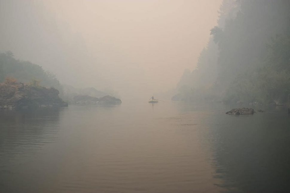 Smoky conditions on the Rogue River
 Firefighter restock gear on one of our rafts
Before long we arrived at Black Bar Lodge, our first drop off point. The place was bustling with activity as crews worked to build a defensible space around the property. That sight stood in marked contrast to what it had been like there just a little over a week ago on my last commercial trip. There was not much time to stay and look around though, as we still had a couple deliveries to make down river.
The next stop was Horseshoe Bend, where crews were stationed in hopes of keeping the fire from jumping the river. If you are familiar with the terrain around Horseshoe Bend, then you will know how difficult it would be to manage a fire that grew beyond the spot fires crews were there to put out. It is one of few spots on the Rogue where someone at river level is afforded a view all the way to the canyon rim, and that is due to the sheer steepness of the surrounding ridge. Again, we quickly offloaded supplies and made another downstream push to our last drop off point of the day, Winkle Bar.
It was at this point in the day, that we first encountered flames at the river’s edge. Chrissy had been on one of the last trips to launch on the Rogue before the fire forced an emergency closure, and had encountered fire as high as the Dulog rapids. On this trip, a few days later we first saw them adjacent to Mary’s Hole (Telephone Hole). For the most part, the fire was smoldering in the underbrush with occasional flare ups do to wind gusts. Further downstream we noticed the brush burned to the edges of both the Dulog and Kelsey camps. I think I was expecting the sort of intense burn you see along the Illinois River as a result of the Biscuit Fire, but was glad to see that was not the case. Of course all it would take to change that is a strong wind, but while we were floating through, the fires were suppressed by a marine influence that kept the flames low and smoldering instead of devastating crown runs.
 Wildfire burning along the Rogue River
Through that section of river, from around Mary’s Hole (Telephone Hole) through Kelsey Canyon, we could actually feel heat from the flames but were for the first time, out of the smoke. By the time we were unloading supplies for the crews stationed at Zane Grey’s cabin on Winkle Bar, the fire was behind us. Crews there were busy covering the structures in a protective wrap that looked like aluminum foil and readying to create a defensible space around them. After offloading the last of the supplies at Winkle Bar, and thanking the crew for all their hard work, we pushed on downstream a safe distance and make camp at Missouri Creek. We went to bed with clear skies, but woke up socked in with the smoke we had hoped to escape, and it remained with us all the way to Foster Bar.
 Chrissy rowing through Mule Creek Canyon
That morning though, we had one more stop to make at Marial Lodge. Here we unloaded a few pumps and things that would be sent back to the Incident Command Post and redeployed as needed. Then, having nearly empty boats, we proceeded through Mule Creek, Blossom Bar, and on through Huggins Canyon hoping to outrun the smoke. We actually did get out of it for the rest of that day, but early the next morning we noticed an unwelcome sight rolling over the nearby ridgetops. It could almost have been a coastal fog rolling in had it not been coming from the wrong way. The same inversion that was helping to keep the fire in check was also forcing the smoke down into the canyon, and at least as of a few days ago was making its way nearly to the coast. We heard from Al, the caretaker at Clay Hill Lodge, that the pattern was a daily event, dependent on the whims of the wind.
We ended our trip, as most people do, at the Foster Bar boat ramp. Like the rest of the river had been, it was as empty there as I had ever seen it. Signs on the bathroom door that must have been meant for the last few trips on the water before the river closed stated Bear Camp Road was closed and there could be shuttle delays.