Why is the Owyhee River geology cool?
The geology of the Lower Owyhee River is unique for several reasons. First, the oldest rocks on the Owyhee are around 16 million years old (Ma). This may seem old; however, geologically speaking this is very young. To give some perspective, the youngest rocks in the Grand Canyon are 245 Ma and the oldest are about 1.8 billion years old; the Appalachian Mountains are around 250 Ma; and the Rocky Mountains started growing about 70 Ma. The oldest rocks of the Owyhee are a mere 16 Ma, with some volcanic rocks as young as 70,000 years old. That’s pretty darn young!
Another thing that’s special about the Owyhee area is how active the river basin has been. Over the last 2 Ma, multiple dams have formed slowing, stopping, and moving the river, but the river fights back and flows on. It’s an ongoing battle with evidence of punches and kicks throughout the river corridor.
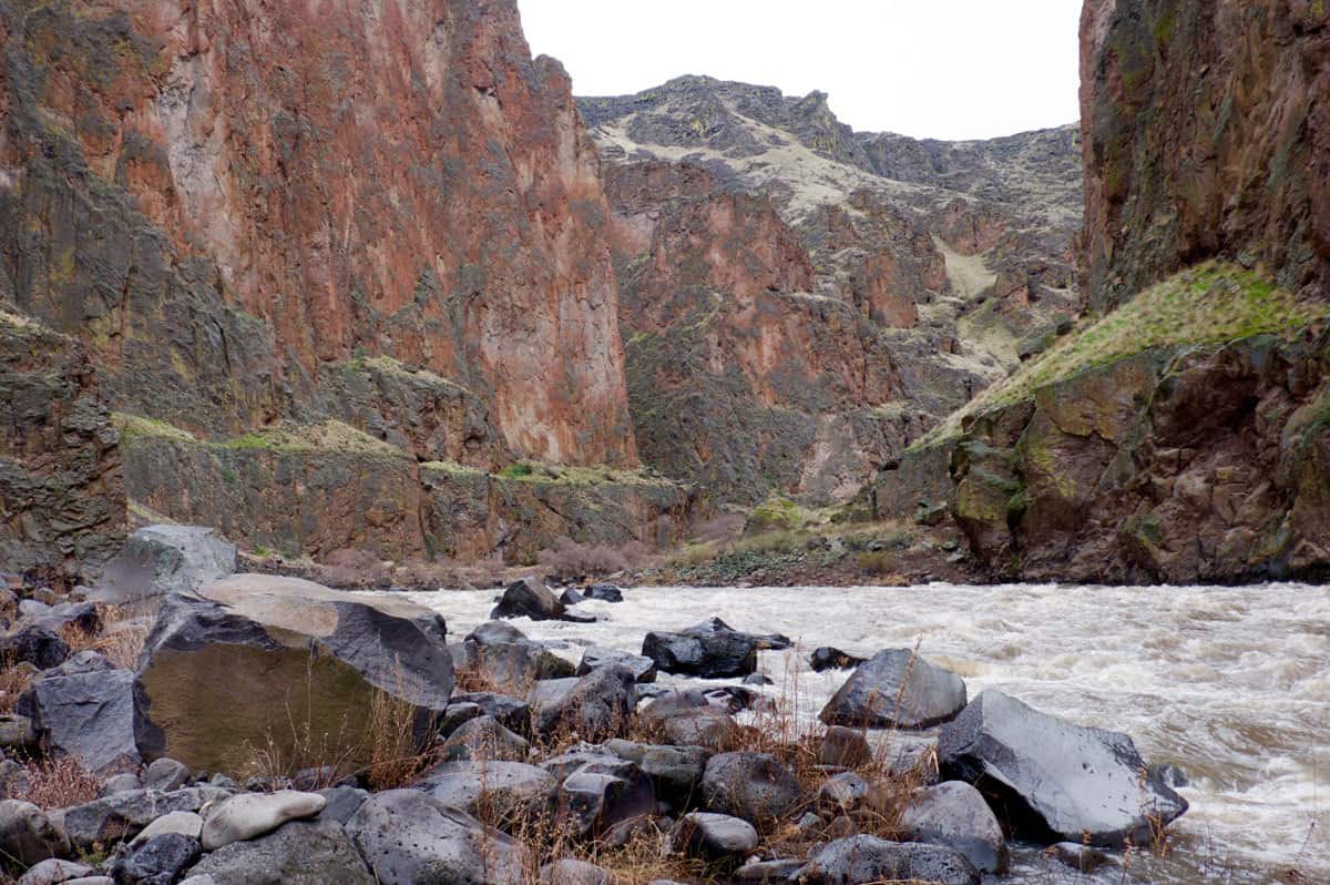
And finally, it looks stinkin’ cool! The tall sheer cliff of pink rhyolite, blocky columnar basalt, black and white layers of lavas and sediments, thin deep red layers of baked clay, green, red, tan, purple, grey, black, white… on and on. Geology jargon aside, it’s beautiful to look at!
Definitions of Geology Lingo
Before we get started, here are a few definitions to help understand some geology words.
Volcanic – A rock that was once magma in the earth, rose up through the crust, and cooled on the surface of the Earth. Volcanic is one of two types of Igneous Rocks. The second type is plutonic, which is magma that then cooled inside the Earth.
Basalt – A type of volcanic rock that is usually dark in color and often breaks into parallel hexagonal columns while cooling. It is richer in iron, magnesium, and calcium. It also flows easier and usually travels further from the caldera.
Rhyolite – Another type of volcanic rock that is usually lighter in color, ranging from cream to tan to pink. Rhyolite is richer in silica, potassium, and sodium, and is more viscous or sticky and does not flow well or far.
Miocene – Miocene Epoch is a section of geologic time from roughly 23 Ma – 5 Ma. Geologic time is broken down into smaller and smaller groups of time. The largest time periods are Eons, then Eras, Periods, and the smallest are Epochs. Throughout this article many rock layers will simply be described as Miocene to give an age estimate.
Hotspot – A hotspot is source of magma rising up from the mantle and erupting on the surface. Slowly over time, plate tectonics move the land over this stationary faucet of magma and a chain of volcanoes result. Yellowstone and the Hawaiian Islands are great examples.
Subduction – A geologic process where oceanic crust slides under continental crust (land). Tens to Thousands of miles of oceanic crust can be subducted into the mantle. A chain of volcanoes are produced on the continental crust and any island in the ocean will get jammed on to the continental crust.
Fault – A fault is when there is a fracture through the crust and the land on either side moves relative to each other parallel to the fracture. In a normal fault the land is spreading and dropping down verses a reverse fault where the land is compressed and getting pushed up.
Basement Rocks
Oregon was created from different islands and landmasses colliding onto the western side of the North American plate through subduction starting around 400 million years ago (Ma). The base rock of Oregon is a huge compilation of all sorts of rocks crammed one next to the other, growing westward eventually creating present-day Oregon. These basement rocks are a canvas for further geologic processes to paint on and create the landscapes we see today. In southeastern Oregon, this basement rock is completely buried and thus the exact rock type is unknown. Never the less, it is there and is a platform for creating what we see now.
Yellowstone Hotspot (17 – 15 Ma)
Yellowstone National Park is an incredible, worldwide known location created by the Yellowstone Hotspot, but lesser known and still being discovered is that the magma creating Yellowstone N.P. originally erupted in eastern Oregon.
15 – 17 Ma the Yellowstone Hotspot first poked its head up on land. The volcanoes created were some of the largest to occur anywhere on earth with some flows traveling 400 miles and single flows covering 10,000 square miles. This created a huge area of volcanoes throughout Washington, Oregon, and Idaho; and created the famous Columbia River Basalts of Columbia Gorge. More importantly, it produced volcanic rhyolite flows in southeastern Oregon that we see along the Owyhee River, most notably Iron Point Canyon. Rhyolite most likely covers a much larger area in southeastern Oregon than seen, but because it has since been buried; only small pockets are exposed from the river cutting down through it.
Although there is still debate, it is thought that the Yellowstone Hotspot sort of looked like a large upside down tear drop rising up through the earth. So when it reached the surface, it created a large area of volcanoes. Once the large head was erupted, the much smaller tail was left and continued to produce magma. As the tectonic plates moved westward, this tail of magma is what created the trail of volcanoes from the Owyhee area through southern Idaho and up to its present day location of Yellowstone N.P.
Period of Extension (15 – 2 Ma)
Starting around 15 Ma, southeastern Oregon begins stretching east to west. The exact causes of this still are not certain, but there are two main hypotheses.
(1) That residual magma from the hotspot is pushing up and stretching the land.
(2) That it is the very northern part of the Basin and Range Province of Nevada and Utah.
The Basin and Range Province is large area of east-west extension created by processes that would take a full research paper to even attempt to explain. Either way the results are the same for southeastern Oregon – north-south running mountains and valleys.
The land, now dotted with rhyolite lava flows, and most likely also spots of basalt, starts to rift, or break apart. North-south normal faults cut through the land creating north-south running mountains and valleys. During this time hundreds of volcanoes break through and cover the southeast third of the state. There is everything from small cinder cones to calderas many miles across and lava flows of all types, although along the Owyhee River, primarily basalt is seen.
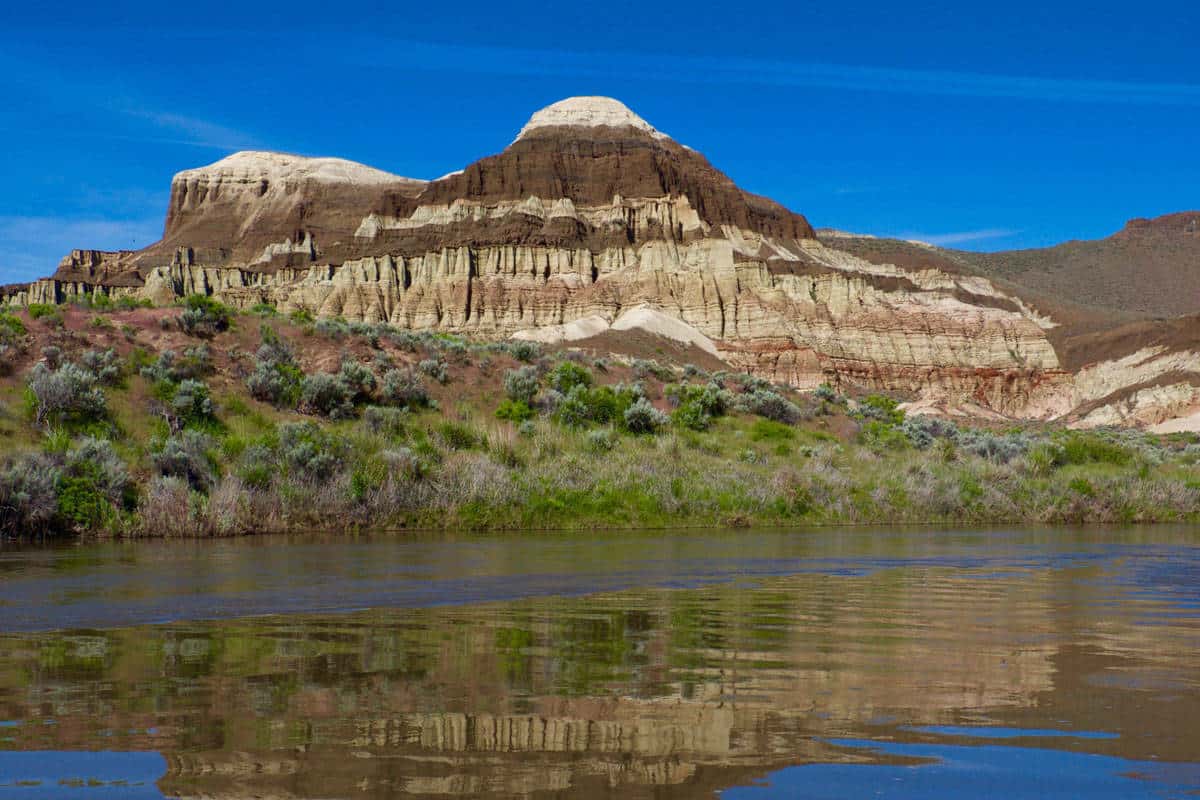
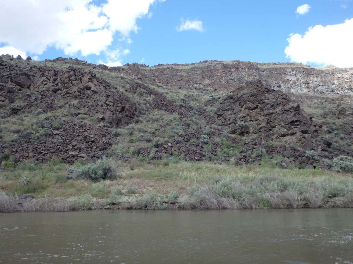
The newly formed valleys also served as great places for water to hold up and hundreds of small lakes evolved during this time. The lakes and volcanoes were constantly interacting. Lakes formed in the valleys, lava flowed into them and forced them to drain, move, or change. New low spots would form and thus new lakes and then eventually lava would flow in again. Often when this hot lava poured onto the bottom of the lakes it would bake the clays of the lakebeds into a hard almost metamorphosed red brick layer. This cycle is seen again and again represented by interbedding layers of lakebed sediments (siltstones, sandstones, gravels) and basalt lava flows. For the sake of simplicity, these layers will be lumped together and referred to as Miocene lake sediments and lava. This is very obvious in the Lambert Rocks area and is also seen in several spots throughout the river.
This entire section roughly river mile 24-28, on river left, was deposited in the Miocene (prior to the Owyhee river), buried, and later exposed by the river. (While all of the basalts on river right are West Crater Lavas, 70,000 years old.)
More Basalt Volcanoes (2Ma – Present)
This is where the story starts getting a little more complicated. There are a series of primarily basalt volcanoes popping up around the Owyhee valley in the last 2 million years. Although lots of them are not seen along the river, several of them are. Unlike sedimentary rocks which naturally lie younger on top of older, lava flows over whatever topography is present and like water flows downhill and fills low points. It is not uncommon to see much younger basalt appearing to be under older sediments or lava.
In general when floating down the river, it is easier to lump all of these younger basalts together and lump all the older Miocene basalts together and attempt to identify the two groups. However, with several recent research projects, if one wanted, the younger basalt can be divided up and identified. Five of the more commonly seen flows and their ages are as follows: Bogus Basin (1.8 Ma), Deer Park (780 ka), Clark’s Butte (215 ka), Saddle Butte (144 ka), and West Crater (70 ka). The main point in mentioning this is give an idea of how complicated the geology really is.
In general, if you see rock that looks more weathered or broken down and appears as though it’s only visible because the river carved down and exposed it, most likely it’s Miocene basalt or sediments. If rocks appear to be sitting on top, or on new ridges in the canyon, and have a stronger structure (less weathering) most likely they are the younger basalt.
On the take out drive from Birch Creek, there are the Jordan Craters which cover hundreds of square miles and are only 3,200 years old. A string of these very young volcanoes dot southeastern Oregon. Although there are no currently active volcanoes in the area, it is fair to assume that at some point in the next few thousands of years the Owyhee will be active again.
The Emerging River, Lava Dams, and Landslide Dams (2Ma – Present)
The exact age of when the Owyhee River began is unknown, but it’s believed to have originated within the last 2 million years. Since it started to flow, just like its preceding Miocene lakes, it too has been in an ongoing battle with the lava. As the river starts to cut down, lava flows come and plug it up. Over time the river either fills the reservoir and slowly starts to cut through the dam, or the river finds a more easily erodible area, such as older lakebed sediments, and finds a new path around the dam. These dams are more of a recent discovery and really ground-breaking for the geology of the area. It’s truly amazing how you can see geology happening here – the fight between river erosion and lava filling in.
When a lake is formed from a dam, deposition occurs forming new lakebed sediments and adding another component to the story. This adds layers of more recent sediments into the mix. From river level it is difficult to determine if the sediments are Miocene or within the more recent last two million years.
Lava Dams
There are two types of dams that form in the Owyhee Canyon – lava dams and landslide dams. Lava dams occur when flowing lava enters the river and blocks the water. Usually once the lava enters the river, it starts to flow both up and downstream. More lava flows in piling on top of itself until it has created a solid dam. Lava dams thus occur at the time of the eruption. These dams are hard to erode through and if possible, the river will erode around them and create a new path until it can get back to its original path.
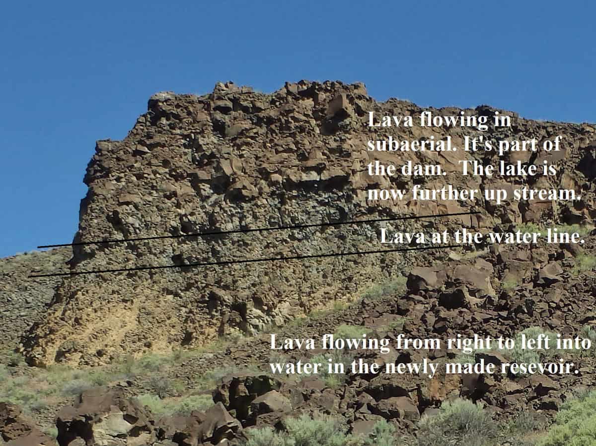
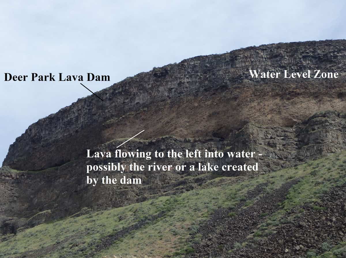
When lava flows into water, either into the river or more common into the lake that it is forming, a very diagnostic appearance is created, as seen in Figure 4. Sections of rock like this are seen in several locations along the river (and they’re really cool!). They signify lava flowing into water. The bottom layer is a yellow-tan color (from weathering) with angled lines of basalt flowing in on top of each other. The angle shows which direction the lava was flowing. Above that section is a thin passage layer where the basalt is right at water level, which is then topped by subaerial lava or above the surface.
There are six lava dams on the river, four of which have known location dam sites which are as follows:
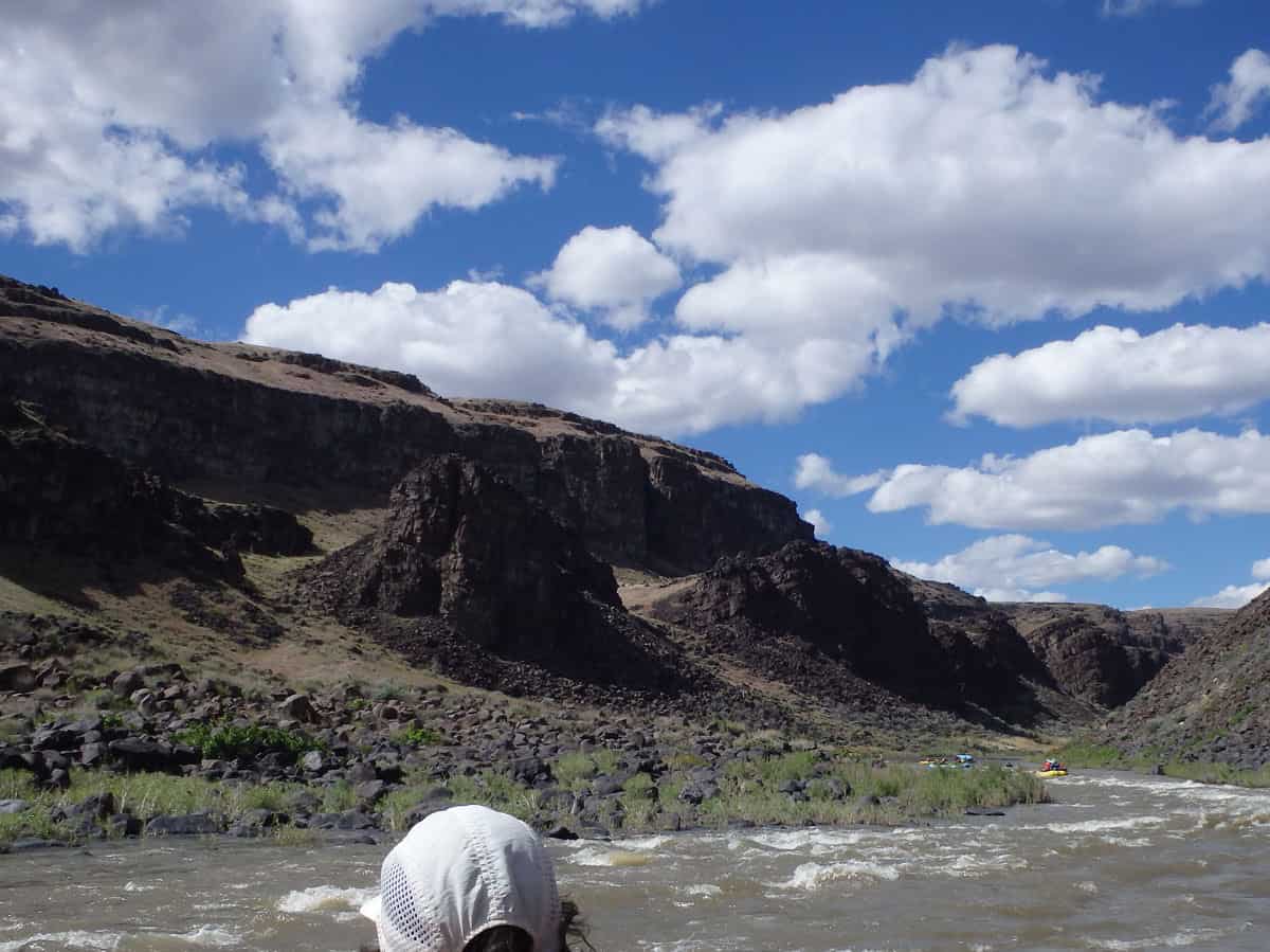
- Saddle Butte Lava Dam – river mile 16 – 21, primarily seen on river left as seen in Figure 4.
- West Crater Lava Dam – river mile 24, roughly across from Pruitt’s Castle, as seen in Figure 5.
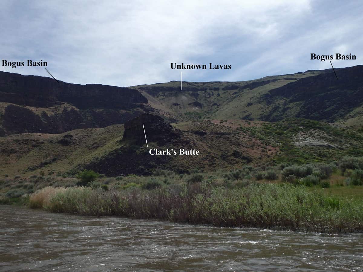
- Bogus Basin Lava Dam – around rive mile 31 where Iron Point Canyon starts. At the time of the dam, around 1.8 Ma, the rhyolite that forms the current Iron Point Canyon had barely been eroded down. Lavas flowed through Bogus Basin Canyon (Figure 5) to the Owyhee and dammed the small river corridor where the entry to Iron Point Canyon is now.
- Deer Park Lava Dam – mile 43-44, on river right up about 60m, across from Greeley hot springs, as seen in Figure 6.
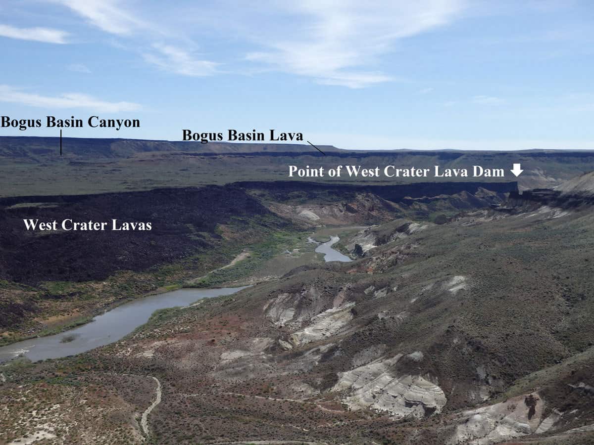
All of the basalt on river right through Lambert Rocks area is the West Crater Lavas at 70,000 years old. All of the rocks on river left are Miocene lakebed sediments and lavas. The Bogus Basin lavas flowed down Bogus Basin Canyon to reach the Owyhee River, creating the Bogus Basin Lava Dam.
Landslide Dams
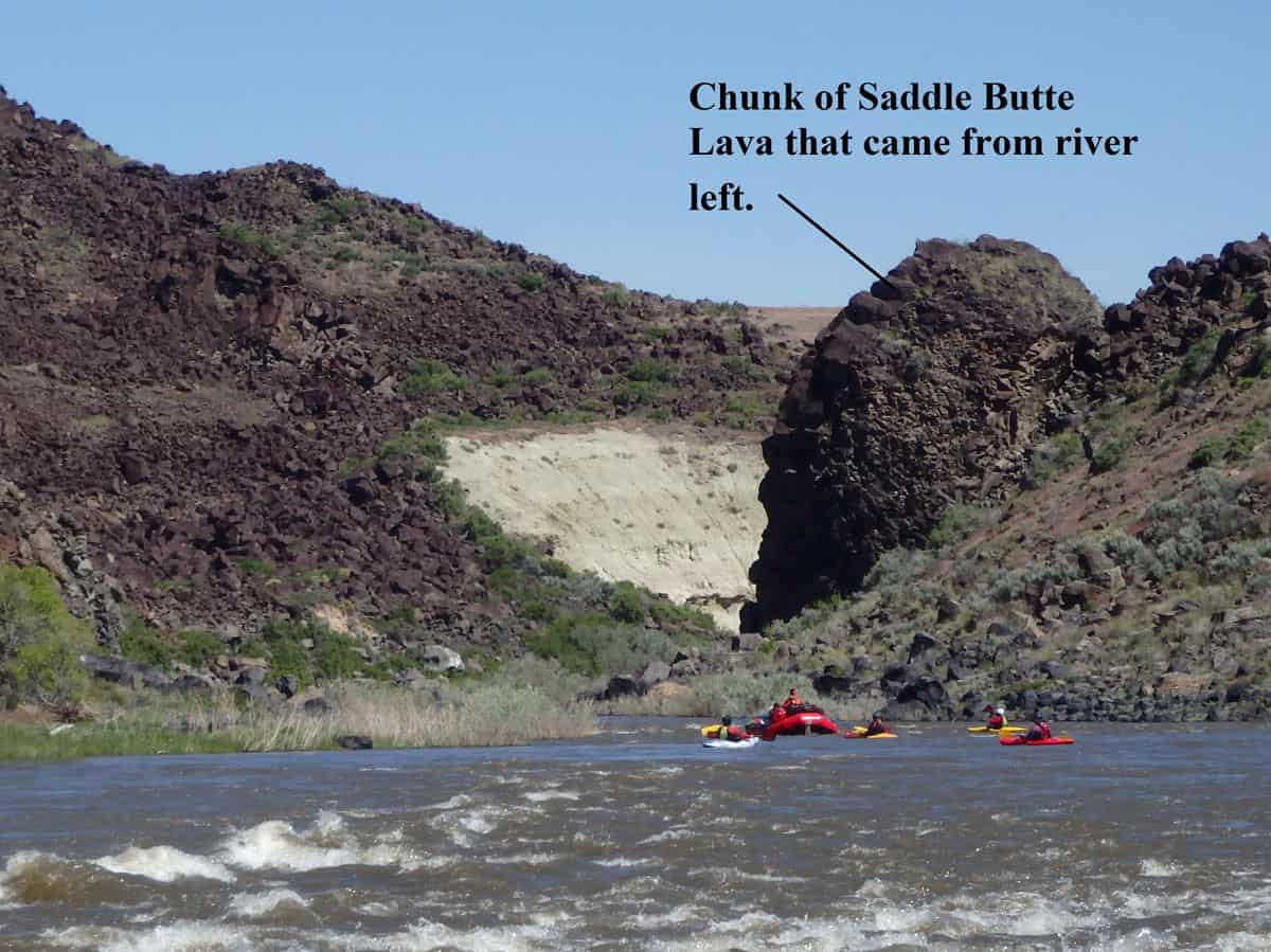
In addition to lava dams there were also landslide dams. As the heavier layers of basalt sit on the more easily erodible lake sediments, at some point a layer in the sediments can slide creating large landslides. The exact catalyst that triggers the slides is unknown. There are multiple spots to see evidence of landslides along the river (Figure 7). These landslides occur sometime after the eruption, cooling, and eroding of the lava. Landslide dams are more easily erodible than lava dams. The river can usually erode through these dams verses carving around them. Often landslide dams can break catastrophically, move large boulders, and erode or smooth out rocks downstream from the mass release of water. The gravel bar on river right, just below Artillery Rapid is an example of this from the Saddle Butte Landslide Dam. (Sorry, no photo)
There is evidence that some of these landslides have dammed up the river. Two examples of this are noted below.
- Mile 13, just above Bulls Eye Rapid. On river left and river right there is debris from basalt slides. Most likely this section of river was once completely blocked by the debris. Figure 8 and 9.
- Saddle Butte Landslide Dam, roughly mile 21, above Read it and Weep Rapid. This is shortly after the Saddle Butte Lava Dam. There is a pinch in the river formed from a large chunk of Saddle Butte Lava on river right that originated up on river left. Figure 10.
The Quick and Dirty Version
- 17 – 15 Ma : Rhyolite from the Yellowstone Hotspot – forms sheer pinkish narrow canyons
- 15 – 2 Ma : Mountains and valleys form from faulting – this creates lakes in the basins and basalt volcanoes from the faults – black (lava) and white (lake seds) layers are formed
- 2 Ma – Present : More recent basalt flows top older rhyolite, basalt, and sediments – Owyhee River forms – these basalts created dams that have changed the course of the river over time
Ok, The Owyhee Geology is Cool… Now What?
Go check it out!! Go climb up the black and white Miocene layers of Lambert Dome, touch the 70,000 year old columns of basalt, crick your neck trying to see the top of Iron Point Canyon, discover the dam sites, camp along the persistent carving river, see the amazing multitudes of colors! Go embrace your inner geologist! You can get a crew of friends, boats, and gear and float the river on your own – permits are easy to get. If you’re lacking in boats and gear, or just want a little extra help, you can go on a commercial rafting trip. End of April and May are usually great times to go. If you want to see more or rafting isn’t quite for you, try a hike around Birch Creek Ranch, Jordan Craters, Leslie Gulch, or Succor Creek State Recreation Area. Enjoy!
Learn more about Geology of the Owyhee River from a coalition of USGS geologic mappers and University researchers that refer to themselves as the Yeehows.
